【 Notes 】TOA Estimation Preliminary introduction
TOA estimation allows the measurement of distance, thus enabling localization. Here, multiple base nodes collaborate to localize a target node via triangulation [3] .
It is assumed that the positions of all base nodes are known. If these nodes are dynamic, a positioning technique such as GPS is used to allow base nodes to localize their positions (GPS – TOA positioning).
In some circumstances, multiple base nodes may cooperate to find their own position before any attempt to localize a target node [4] .
TOA估计可以被使用进行定位,但是我们的假设条件是所有基节点的位置是已知的。所谓的基节点的意思是对目标进行定位的测量站。
如果基节点是动态的,那么我们就要借助于全球定位系统(GPS)确定基节点的位置。这种情况下的定位称为GPS—TOA定位系统。
还有一些环境下,多个基节点可以通过相互合作确定他们自己的位置。
这就是说,如果使用TOA进行定位,我们就必须提前知道测量站(基节点)自身的位置,之后才能对目标进行定位。
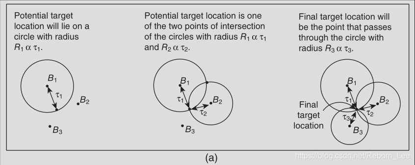
Assuming known positions of base nodes and a coplanar scenario, three base nodes and three measurements of distances (TOA) are required to localize a target node (see Fig. 1.2 a).
假设已知基节点位置且为共面场景,需要三个基本节点和三个距离测量(TOA)来定位目标节点(参见图1.2a)。
In a non - coplanar case, four base nodes are required.
非共面场景,需要四个基节点。
Using the measurement of distance, the position of a target node is localized within a sphere of radius  with the receiver i at the center of the sphere (where
  is directly proportional to the TOA
  as shown in Figure 1.2 a. The localization of the target node can be carried out either by base nodes using a master station or by the target node itself.
使用距离测量,目标节点的位置定位在半径 范围内,接收器i位于球体的中心(其中
 与TOA
与TOA 成正比,如图1.2a所示。目标节点的定位 可以由使用主站的基节点或由目标节点本身执行。(理解下这句话)

Figure 1.2 (a) Operation of TOA
Although TOA seems to be a robust technique, it has a few drawbacks [5] :
1. It requires all nodes (base nodes and target nodes) to precisely synchronize: A small timing error may lead to a large error in the calculation of the distance  .
.
2. The transmitted signal must be labeled with a time stamp in order to allow the base node to determine the time at which the signal was initiated at the target node. This additional time stamp increases the complexity of the transmitted signal and may lead to an additional source of error.
3. The positions of the base nodes should be known; thus, either static nodes or GPS - equipped dynamic nodes should be used.
虽然TOA似乎是一种强大的技术,但它有一些缺点[5]:
1.它要求所有节点(基本节点和目标节点)精确同步:小的定时误差可能导致距离计算中的大误差。
2.必须用时间戳标记发送的信号,以便允许基节点确定在目标节点处发起信号的时间。 这种额外的时间标记增加了发送信号的复杂性,并可能导致额外的错误源。
3.应知道基节点的位置; 因此,应该使用静态节点或配备GPS的动态节点。
文章来源: reborn.blog.csdn.net,作者:李锐博恩,版权归原作者所有,如需转载,请联系作者。
原文链接:reborn.blog.csdn.net/article/details/84067340
- 点赞
- 收藏
- 关注作者


评论(0)