微信小程序 地图定位、选址,解决regionchange重复调用

【摘要】
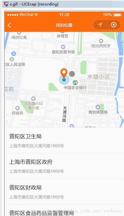
效果:
需求
定位到当前位置,并查询周边的地址显示到列表中,且地图可以拖动选取位置
实现
1,在wxml中添加视图view
<map id="map"
longitude="{{my...
效果:
需求
定位到当前位置,并查询周边的地址显示到列表中,且地图可以拖动选取位置
实现
1,在wxml中添加视图view
<map id="map"
longitude="{{myLongitude}}"
latitude="{{myLatitude}}"
scale="18"
bindcontroltap="controltap"
markers="{{markers}}"
controls="{{controls}}"
bindmarkertap="markertap"
bindregionchange="regionchange"
show-location
style="width: 100%; height: 300px;"></map>
- 1
- 2
- 3
- 4
- 5
- 6
- 7
- 8
- 9
- 10
- 11
- id是这个map组件标识
- longitude、latitude是经纬度,确定一个位置
- scale 缩放比例
- markers地图上的标记
- bindmarkertap 点击标记触发,返回marker的id
- controls控件,可以加两个图标控制地图缩放
- bindcontroltap 点击控件触发,会返回控件的id
- bindregionchange 视野发生变化时触发
- show-location 是否显示位置
2,js中处理逻辑
1.data中初始化数据
    data: {
          myLatitude: 0.0,
          myLongitude: 0.0,
     },
- 1
- 2
- 3
- 4
2.onLoad中初始化腾讯地图(官方文档)和获取当前位置并更新
     onLoad: function(options) {
          var that = this
          // 实例化API核心类
          qqmapsdk = new QQMapWX({
               key: 'your key'
          });
          wx.getLocation({
               type: 'gcj02',
               success: function(res) {
                    console.log(res);
                    that.setData({
                         myLatitude: res.latitude,
                         myLongitude: res.longitude,
                    });
               }
          })
     },
- 1
- 2
- 3
- 4
- 5
- 6
- 7
- 8
- 9
- 10
- 11
- 12
- 13
- 14
- 15
- 16
- 17
3.在onReady中初始化操作,获取中间点的经纬度,并标记出来
    onReady: function() {
          this.getLngLat()
     },

     //获取中间点的经纬度,并mark出来
     getLngLat: function() {
          var that = this;
          this.mapCtx = wx.createMapContext("map");
          this.mapCtx.getCenterLocation({
               success: function(res) {
                    that.setData({
                         markers: [{
                              id: 0,
                              iconPath: "../../images/location1.png",
                              longitude: res.longitude,
                              latitude: res.latitude,
                              width: 40,
                              height: 40
                         }]
                    })
                    that.getPoiList(res.longitude, res.latitude)
               }
          })
     },
- 1
- 2
- 3
- 4
- 5
- 6
- 7
- 8
- 9
- 10
- 11
- 12
- 13
- 14
- 15
- 16
- 17
- 18
- 19
- 20
- 21
- 22
- 23
- 24
【注意】getLngLat()这个方法做了抽取,因为不光初始化要调用,且在视野发生变化的时候也要调用
    //视野发生变化时触发
     regionchange(e) {
          if (e.type == 'end') {
               this.getLngLat()
          } else { //begin
          }
     },
- 1
- 2
- 3
- 4
- 5
- 6
- 7
【重点来了】在regionchange方法中操作经纬度会出现bug,会频繁调用,标记也会一直闪,目前官方还没有修复,网上给的解决方案是临时定义变量接收,这里是直接拿着参数去用了,即that.getPoiList(res.longitude, res.latitude) 中的两个参数
4.获取周边的地址列表
wxml
<block wx:for="{{addressList}}" wx:for-item="item" wx:for-index="index" wx:key="item.orderId">
     <view class="weui-media-box weui-media-box_text" bindtap='clickItem' data-title='{{item.title}}' data-address='{{item.address}}' style='background-color:#fff;'>
          <view class="weui-media-box__title weui-media-box__title_in-text">{{item.title}}</view>
          <view class="weui-media-box__desc">{{item.address}}</view>
     </view>
</block>
- 1
- 2
- 3
- 4
- 5
- 6
js
     getPoiList: function(longitude, latitude) {
          var that = this
          // 调用接口
          qqmapsdk.reverseGeocoder({
               location: {
                    latitude: latitude,
                    longitude: longitude,
               },
               get_poi: 1,
               poi_options: 'policy=2;radius=3000;page_size=20;page_index=1',
               success: function(res) {
                    that.setData({
                         addressList: res.result.pois
                    })
               },
               fail: function(res) {
                    console.log(res);
               },
               complete: function(res) {
                    console.log(res);
               }
          });
     },

     clickItem: function(e) {
          let pages = getCurrentPages();
          let prevPage = pages[pages.length - 2];
          prevPage.setData({
               address: e.currentTarget.dataset.address,
          })
          wx.navigateBack({
               delta: 1,
          })
     },
- 1
- 2
- 3
- 4
- 5
- 6
- 7
- 8
- 9
- 10
- 11
- 12
- 13
- 14
- 15
- 16
- 17
- 18
- 19
- 20
- 21
- 22
- 23
- 24
- 25
- 26
- 27
- 28
- 29
- 30
- 31
- 32
- 33
- 34
根据当前中心点的经纬度及其他参数去获取位置列表,然后显示到页面中
点击某一条位置的时候带参数返回上一页
文章来源: blog.csdn.net,作者:yechaoa,版权归原作者所有,如需转载,请联系作者。
原文链接:blog.csdn.net/yechaoa/article/details/82015804

【版权声明】本文为华为云社区用户转载文章,如果您发现本社区中有涉嫌抄袭的内容,欢迎发送邮件进行举报,并提供相关证据,一经查实,本社区将立刻删除涉嫌侵权内容,举报邮箱:
cloudbbs@huaweicloud.com
- 点赞
- 收藏
- 关注作者
评论(0)