ECEF rectangular coordinate system(ECEF直角坐标系)

只有当有定位的需要时,才发现当年自己地理学的不太好,经纬度什么的都不是太清晰,麻烦了。今日以ECEF position为契机,参考维基百科以及一些叫不上名字的文章来简单地总结一番。
参考地址:
https://en.wikipedia.org/wiki/ECEF
http://www.cnblogs.com/nimo299/p/4332614.html

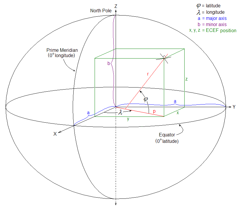
Figure 1.1 : ECEF rectangular coordinate system.
先给出上面的两个名词的翻译:
Prime Meridian:本初子午线
Equator:赤道
The usual rectangular coordinate system [x, y, z], here in referred to as the ECEF coordinate system, has its origin at the Earth’s center of mass with its x-axis extend through the intersection of the prime meridian (0deg longitude) and the equator (0deglatitude). The z-axis extends through the true north pole (i.e., coincident with the Earth spin axis). The y-axis completes the right-handed coordinate system, passing through the equator and 90deg longitude, as shown in Figure 1.1.
如图1.1所示,通常的直角坐标系[x,y,z],这里称为ECEF坐标系,其起源位于地球的质心,其x轴延伸通过本初子午线(0度经度)和赤道(0deglatitude)的交点。 z轴延伸通过真正的北极(即,与地球旋转轴重合)。 y轴完成右手坐标系,穿过赤道和90度经度。
知道了x,y,z坐标系的规定,再看看下面这张图,看看经纬度是如何确定的:
翻译两个单词,我相信有些人对此还是有点障碍的:
latitude:经度
longitude:维度
north pole:北极
major axis:主轴
minor axis:短轴
如此以来,上图中的目标位置也就确定了,从图上看,用ECEF直角坐标系表示为(x,y,z)。
以上都是最简单的常识,有兴趣了我再总结其他的,例如大地坐标系(the geodetic coordinate systems ),这篇文章中有提到:http://what-when-how.com/gps-with-high-rate-sensors/ecef-coordinate-systems-gps/
文章来源: reborn.blog.csdn.net,作者:李锐博恩,版权归原作者所有,如需转载,请联系作者。
原文链接:reborn.blog.csdn.net/article/details/82494266

- 点赞
- 收藏
- 关注作者
评论(0)