【 Notes 】GPS Preliminary introduction
GPS
The GPS is based on a man - made constellation of 27 Earth - orbiting satellites (24 in operation and 3 extras in case one fails). Using these satellites, a person or object can localize its position in terms of latitude, longitude, and altitude [1] . These satellites orbit the earth at an altitude of 12,000 miles and complete two rotations each 24 hours. The orbits of these satellites are arranged such that at any given time, anywhere on the earth, at least four satellites are clearly visible. A GPS receiver placed on the earth can localize its position using any set of four visible satellites.
全球定位系统基于人造星座,由27颗地球轨道卫星组成(运行中24颗,另外3颗发生故障)。 使用这些卫星,人或物体可以根据纬度,经度和海拔来定位其位置[1]。 这些卫星在12,000英里的高度环绕地球运行,每24小时完成两次旋转。 这些卫星的轨道被安排成使得在任何给定时间,地球上的任何地方,至少四颗卫星清晰可见。 放置在地球上的GPS接收器可以使用任何一组四颗可见卫星定位其位置。
While GPS can be effectively used for many navigational applications, it has limitations. It is not capable of positioning within buildings and mines due to signal attenuation. Its performance is also degraded in severe scattering environments, such as downtown urban areas. GPS is a self - positioning system. To enable this system for remote positioning, which is required for applications such as ad hoc networks, each node should be equipped with a communication system as well to transmit the self - localized data to other nodes. In addition, because GPS transmission features are known, these systems might be jammed by an adversary. This also limits its defense applications. Systems such as INS can be fused with GPS to enable localization in indoor areas and mines. In addition, WLPSs have been developed to enable localization in GPS - denied environments.
虽然GPS可以有效地用于许多导航应用,但它具有局限性。 由于信号衰减,它无法定位在建筑物和矿井内。 其性能在严重的散射环境中也会降低,例如市中心区域。 GPS是一种自定位系统。 为了使该系统能够进行远程定位,这是ad hoc网络(What does Ad Hoc Network mean?)等应用所必需的,每个节点都应配备通信系统,以便将自定位数据传输到其他节点。 另外,由于GPS传输特征是已知的,因此这些系统可能被对手干扰。 这也限制了其防御应用。 INS等系统可与GPS融合,实现室内区域和矿井的定位。 此外,WLPS已经开发出来,可以在GPS拒绝的环境中实现定位。
Two pieces of information are required to carry out the localization process via GPS:
1. The distance from the GPS receiver to satellites
2. The position of each satellite in terms of its latitude, longitude, and altitude (see Fig. 1.3 a)
通过GPS执行本地化过程需要两条信息:
1.从GPS接收器到卫星的距离
2.每颗卫星在纬度,经度和海拔高度上的位置(见图1.3a)
The receiver collects these pieces of information and analyzes and processes high - frequency, low - power radio signals received from the satellites.
接收器收集这些信息并分析和处理从卫星接收的高频,低功率无线电信号。
Mathematical details of localization using GPS are discussed in Chapters 22 , 28 , and 29 of this handbook.
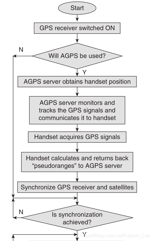
流程图放大:


Distance Measurement
Assuming that the clocks of a GPS receiver and a satellite are perfectly synchronized, the distance is measured using TOA estimation.
Specifically, the lag between the signal transmitted by the satellite and the one generated at the GPS receiver is used to determine the distance (see Fig. 1.3 a). Assuming that the satellite begins transmitting a long unique pattern (a pseudorandom code) at midnight and the GPS receiver also starts generating the same pattern at midnight, the lag is determined by comparing the two patterns.
假设GPS接收器和卫星的时钟完全同步,则使用TOA估计来测量距离。
具体地说,卫星发射的信号与GPS接收机产生的信号之间的滞后用于确定距离(见图1.3a)。 假设卫星在午夜开始发送长唯一模式(伪随机码)并且GPS接收器也在午夜开始生成相同模式,则通过比较两种模式来确定滞后。
As mentioned earlier, clock synchronization is required down to nanosecond precision for accurate calculations. Therefore, under ideal conditions, both the receiver and satellite should be equipped with high - precision clocks, for example, atomic clocks. However, since these clocks are expensive, the receiver manufacturers usually use ordinary quartz clocks. Because these clocks cannot be synchronized to nanosecond precision, there is need for an extra step. This step is called synchronization .
如前所述,时钟同步需要低至纳秒的精度才能进行精确计算。 因此,在理想条件下,接收器和卫星都应配备高精度时钟,例如原子钟。 然而,由于这些时钟很昂贵,接收器制造商通常使用普通的石英钟。 由于这些时钟不能同步到纳秒精度,因此需要额外的步骤。 此步骤称为同步。
In this step, a fourth satellite is used to determine the error in the receiver clock. Because the satellite transmits a long signal, the spheres generated from three satellite measurements are certainly large enough to intersect each other and to produce two possible candidates for the position of the GPS receiver.
在该步骤中,使用第四卫星来确定接收器时钟中的误差。 由于卫星发射长信号,因此从三次卫星测量产生的球体肯定大到足以相互交叉并产生两个可能的GPS接收器位置候选者。
When the receiver and satellite clocks are perfectly synchronized, the intersecting point closer to the earth is considered as the position of the receiver. The sphere that may be generated from a fourth measurement would certainly intersect at this position.
当接收器和卫星时钟完全同步时,更接近地球的交叉点被认为是接收器的位置。 可以从第四次测量产生的球体肯定会在该位置处相交。
However, when receiver and satellite clocks are not synchronized, it is unlikely that the surface of the fourth sphere passes through either of the two intersecting points. The difference between the distance of the estimated receiver position from the fourth satellite and the pseudorange of the fourth satellite (the radius of the fourth satellite or the distance to the fourth satellite as measured by the GPS receiver) is used to calculate the error.
然而,当接收器和卫星时钟不同步时,第四球体的表面不太可能通过两个交叉点中的任何一个。 估计的接收器位置与第四卫星的距离与第四卫星的伪距(第四卫星的半径或由GPS接收器测量的到第四卫星的距离)之间的差异用于计算误差。
In addition to the synchronization of ordinary quartz receiver clocks, the satellite atomic clocks [11] are also corrected periodically. This periodic correction is required to ensure that the relativistic effects are removed and the satellite atomic clocks are synchronized to the ground atomic clocks. These relativistic effects are based on two phenomena explained by the theory of relativity:
(1) The clocks tick faster when they are in a weak gravitational fi eld,
and (2) the clocks tick slower when they moving.
除了普通石英接收器时钟的同步之外,还定期校正卫星原子钟[11]。 需要这种周期性校正以确保消除相对论效应并且卫星原子钟与地面原子钟同步。 这些相对论效应是基于相对论解释的两种现象:
(1)当它们处于弱引力场时,时钟滴答得更快,
(2)时钟在移动时打得更慢。
Thus, an atomic clock on the satellite ticks faster compared with an atomic clock on the ground due to weaker gravitational fi eld in orbit, and it ticks slower because of relatively higher speed. Although theoretically the two effects cancel each other, in the case of a GPS satellite clock, the net effect is faster ticks relative to the atomic clock on the ground. Periodic on - board calculations are performed to correct the satellite atomic clock and to remove the relativistic effects.
因此,由于轨道中的重力场较弱,卫星上的原子钟与地面上的原子钟相比更快,并且由于相对较高的速度,它的速度较慢。 虽然理论上两种效应相互抵消,但在GPS卫星时钟的情况下,净效应相对于地面上的原子钟更快。 执行定期的机载计算以校正卫星原子钟并消除相对论效应。
Satellite Positions
This second piece of information is obtainable with little difficulty as the GPS receiver can simply store an almanac that determines the position of every satellite at any given time. The effect of the gravitational pull of the moon and the sun on the satellites ’ orbits is constantly monitored by the U.S.
由于GPS接收器可以简单地存储在任何给定时间确定每个卫星的位置的历书,因此可以毫不费力地获得该第二条信息。 美国不断监测月球和太阳引力对卫星轨道的影响。
Department of Defense, which conveys any adjustments to all GPS receivers as part of the transmitted signals. When the information on the distance from satellites and their positions is known, multilateration (a process similar to triangulation in TOA) is used to fi nd the three - dimensional position of a GPS receiver.
国防部,作为传输信号的一部分,对所有GPS接收机进行任何调整。 当关于距卫星的距离及其位置的信息已知时,使用多点定位(类似于TOA中的三角测量的过程)来找到GPS接收器的三维位置。
文章来源: reborn.blog.csdn.net,作者:李锐博恩,版权归原作者所有,如需转载,请联系作者。
原文链接:reborn.blog.csdn.net/article/details/84075267
- 点赞
- 收藏
- 关注作者


评论(0)