蓝碳在美国各地湿地和沿海生态系统中的储存情况如何?对应的优先级分布是怎样的?

【摘要】 Blue Carbon-based Natural Climate Solutions, Priority Maps for the U.S., 2006-2011简介数据集"Blue Carbon-based Natural Climate Solutions, Priority Maps for the U.S., 2006-2011"包括了2006年至2011年间美国的蓝碳自然气候解...
Blue Carbon-based Natural Climate Solutions, Priority Maps for the U.S., 2006-2011
简介
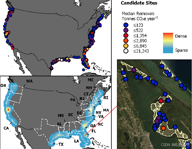
数据集"Blue Carbon-based Natural Climate Solutions, Priority Maps for the U.S., 2006-2011"包括了2006年至2011年间美国的蓝碳自然气候解决方案的优先地图。这些地图显示了在蓝碳基础上采取的自然气候解决方案在美国各地的优先级分布情况。蓝碳是指通过保护、恢复和有效管理湿地、沿海生态系统等地方储存的碳。这些数据对于制定气候变化应对政策和保护生态系统具有重要价值。
摘要
Table 1. Attributes in the shapefiles.
| Attribute | Units | Description |
|---|---|---|
| FID | integer | Field identifier. A unique integer for each site. |
| State | State. A two- character abbreviation indicating which United States state or states the restoration candidate parcel intersects. | |
| Locl_nm | Local name. The local name of the management entity the restoration candidate parcel intersects according to the U.S. Geological Survey's Protected Areas Database. | |
| Lcl_mng | Local manager. The local name of the manager of the restoration candidate parcel intersects according to the U.S. Geological Survey's Protected Areas Database. | |
| Mngr_nm | Manager name. The federal-level name of the manager of the restoration candidate parcel intersects according to the U.S. Geological Survey's Protected Areas Database. | |
| Mngr_ty | Manager type. The type of manager of the restoration candidate parcel according to the U.S. Geological Survey's Protected Areas Database: Types: "Federal", "State", "Local Government", "Non-governmental Organization", "Regional Agency Special District", "Private", or a combination of these types. |
|
| Lat_dd | degrees north | Latitude in decimal degrees. |
| Lon_dd | degrees east | Longitude in decimal degrees. |
| Dom_Rest | Dominant restoration category. The dominant type of restoration category for the parcel according to current status and wetland salinity. Types: "impounded estuarine to estuarine", "impounded palustrine to palustrine", "impounded open water to palustrine", "impounded open water to estuarine", "impounded palustrine to estuarine", "drained agricultural to estuarine", "drained bare to estuarine", "drained grass to estuarine", "drained forest to estuarine". |
|
| Area_ha | ha | Area of the restoration parcel in hectares. |
| M_TCO2e | 103 kg | Median removal of greenhouse gases in metric tons of carbon dioxide equivalent. |
| L_TCO2e | 103 kg | Lower bound of 95% credible interval for estimated removal of greenhouse gases in metric tons of carbon dioxide equivalent. |
| H_TCO2e | 103 kg | Upper bound of 95% credible interval for estimated removal of greenhouse gases in metric tons of carbon dioxide equivalent. |
代码
引用
Holmquist, J.R., M. Eagle, R.L. Molinari, S. Nick, L.C. Stachowicz, and K. Kroeger. 2022. Blue Carbon-based Natural Climate Solutions, Priority Maps for the U.S., 2006-2011. ORNL DAAC, Oak Ridge, Tennessee, USA.

【声明】本内容来自华为云开发者社区博主,不代表华为云及华为云开发者社区的观点和立场。转载时必须标注文章的来源(华为云社区)、文章链接、文章作者等基本信息,否则作者和本社区有权追究责任。如果您发现本社区中有涉嫌抄袭的内容,欢迎发送邮件进行举报,并提供相关证据,一经查实,本社区将立刻删除涉嫌侵权内容,举报邮箱:
cloudbbs@huaweicloud.com
- 点赞
- 收藏
- 关注作者
评论(0)