Urban Sky 最近提供了从洛杉矶大火上空捕获的开放且免费的高分辨率航空和热成像图像

【摘要】 简介Urban Sky 最近提供了从洛杉矶大火上空捕获的开放且免费的高分辨率航空和热成像图像。该数据集包括 10 厘米分辨率的 RGB 图像和 3 米分辨率的远红外(LWIR)热成像图像,覆盖重点为野火事件和城市区域。Microballoon 平台在 15-21 公里的高度运行,提供独特的视角,避免干扰灭火飞机的同时保持高分辨率成像能力。数据集说明空间信息图像共享的技术规格RGB Ima...
简介
Urban Sky 最近提供了从洛杉矶大火上空捕获的开放且免费的高分辨率航空和热成像图像。该数据集包括 10 厘米分辨率的 RGB 图像和 3 米分辨率的远红外(LWIR)热成像图像,覆盖重点为野火事件和城市区域。Microballoon 平台在 15-21 公里的高度运行,提供独特的视角,避免干扰灭火飞机的同时保持高分辨率成像能力。
数据集说明
空间信息
图像共享的技术规格
RGB Imagery Specifications
RGB 影像规格
| Parameter 参数 | Value 价值 |
|---|---|
| Spatial Resolution 空间分辨率 | 10.0 cm 10.0 厘米 |
| Flight Altitude 飞行高度 | 15-21 km 15-21 公里 |
| Sensor Bands 传感器波段 | Red, Green, Blue (RGB) 红色,绿色,蓝色(RGB) |
| Sensor Color Sampling 传感器颜色采样 | RGGB color filter array RGBG 颜色滤光阵列 |
| Sensor Dynamic Range 传感器动态范围 | 12 bits per sample 12 位每样本 |
| Product Dynamic Range 产品动态范围 | 8 bits per sample 每样本 8 位 |
| Single Path Swath Width 单路径幅宽 |
10.5-15.0 km (altitude dependent) 10.5-15.0 公里(海拔相关) |
| Off-nadir Look Angle 天底外视角 | 20° ± 3° |
| Geolocation Accuracy (CE90) 地理位置精度(CE90) |
3 meters 3 米 |
| File Format 文件格式 | Cloud-optimized GeoTiffs 云优化 GeoTiff |
| Processing 处理 | Non-uniformity correction, Edge preserving noise reduction, Adaptive tonal curves 非均匀性校正,边缘保留噪声减少,自适应色调曲线 |
| Compression 压缩 | High-quality YCbCr JPEG 高质量 YCbCr JPEG |
LWIR Thermal Imagery Specifications
长波红外热成像规格
| Parameter 参数 | Value 价值 |
|---|---|
| Spatial Resolution 空间分辨率 | 3.0 m 3.0 米 |
| Flight Altitude 飞行高度 | 15-21 km 15-21 公里 |
| Spectral Band 光谱波段 | 8μm - 14μm |
| Swath Width 行宽 | 10-18 km (altitude dependent) 10-18 公里(海拔相关) |
| Coverage Rate 覆盖率 | 50-1,500 km² per hour (1000 km²/hr typical) 每小时 50-1,500 平方公里(典型值为 1,000 平方公里/小时) |
| Scene Dynamic Range 场景动态范围 | High Gain: Up to 140°C, Low Gain: Up to 500°C 高增益:高达 140°C,低增益:高达 500°C |
| Pixel Pitch 像素间距 | 12 μm 12 微米 |
| Thermal Sensitivity 热灵敏度 | 60 mK |
| Compatible Wind Speeds 兼容风速 | 5-90 km/hr 5-90 公里/小时 |
Note: STAC metadata was provided with the two images but there href links to the data were missing.
注意:提供了两张图片的 STAC 元数据,但缺少了指向数据的 href 链接。
数据集预处理
STAC 元数据被解析以创建图像波段名称的属性,捕获的波段被标记为红色、绿色、蓝色或热红外波段以表示长波红外波段。
代码
var HIGHRES_RGB = ee.Image("projects/sat-io/open-datasets/URBAN_SKY/USKY01_D00236_010_11S_20250119_20250125200840_A0_000_000_01");
var LWIR_THERMAL = ee.Image("projects/sat-io/open-datasets/URBAN_SKY/USKY02_D00235_400_11S_20250119_20250121015227_A2_000_000_01");
Map.centerObject(LWIR_THERMAL,10)
Map.addLayer(HIGHRES_RGB.mask(HIGHRES_RGB.gt(0)),{},'High Res RGB 10cm')
Map.addLayer(LWIR_THERMAL, {min: 3, max: 215, palette: ['#313695', '#4575b4', '#74add1', '#abd9e9', '#fee090', '#fdae61', '#f46d43', '#d73027']}, 'LWIR Thermal 3m')
var snazzy = require("users/aazuspan/snazzy:styles");
snazzy.addStyle("https://snazzymaps.com/style/15/subtle-grayscale", "Greyscale");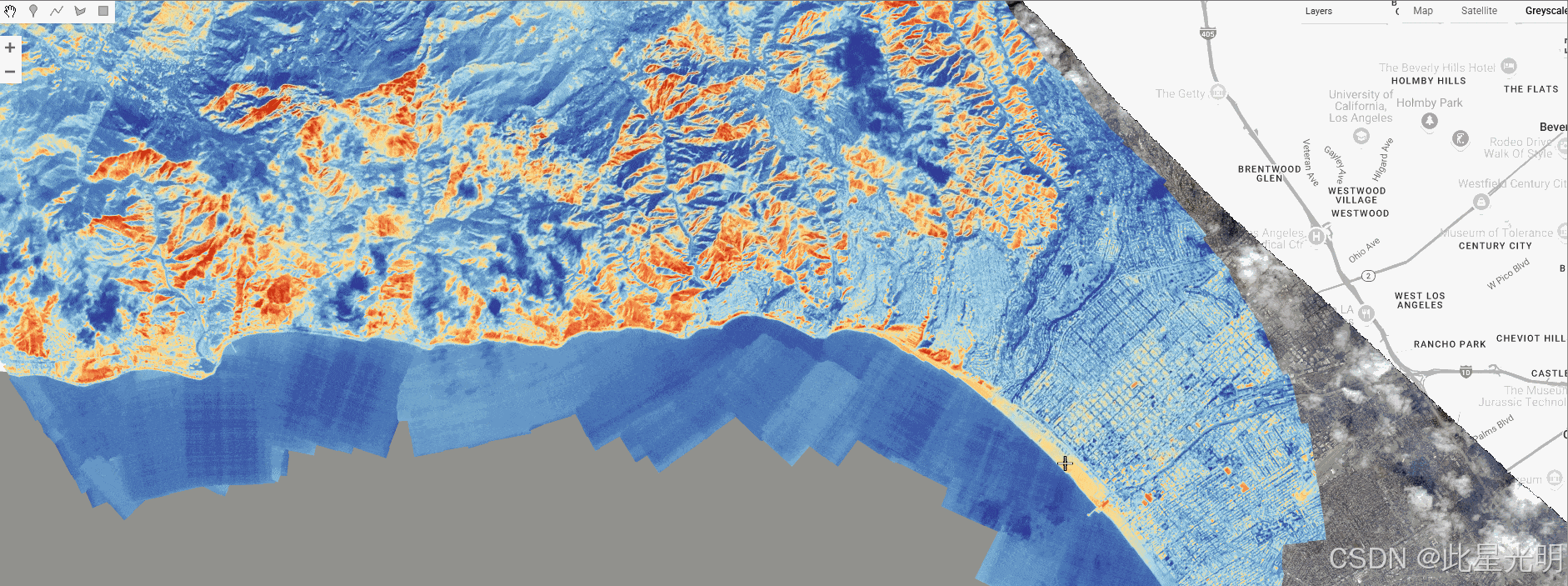 代码
代码
关于数据或合作机会的问题,请联系 Urban Sky,邮箱 info@urbansky.com
许可
This dataset is made available under Creative Commons Attribution 4.0 International License (CC BY 4.0).
由 Samapriya Roy 在 GEE 中整理
Keywords: aerial imagery, thermal imaging, wildfire monitoring, high-resolution imagery, microballoon, stratospheric imaging, LWIR, RGB imagery
关键词:航空影像、热成像、野火监测、高分辨率影像、微型气球、平流层成像、长波红外、RGB 影像
知识星球
机器学习
干旱监测平台

【声明】本内容来自华为云开发者社区博主,不代表华为云及华为云开发者社区的观点和立场。转载时必须标注文章的来源(华为云社区)、文章链接、文章作者等基本信息,否则作者和本社区有权追究责任。如果您发现本社区中有涉嫌抄袭的内容,欢迎发送邮件进行举报,并提供相关证据,一经查实,本社区将立刻删除涉嫌侵权内容,举报邮箱:
cloudbbs@huaweicloud.com
- 点赞
- 收藏
- 关注作者
评论(0)