GHSL:1975-2030 年全球网格人口和建成面积数据为基础(5 年为间隔)

GHSL: Degree of Urbanization 1975-2030 V2-0
GHSL:1975-2030 年全球网格人口和建成面积数据为基础(5 年为间隔)
简介
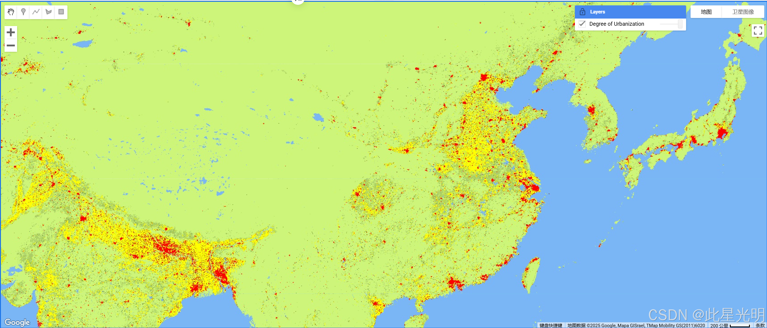
该栅格数据集采用联合国统计委员会推荐的 "城市化程度 "第一阶段方法,以全球人类地理信息系统(GHSL)项目生成的 1975-2030 年全球网格人口和建成面积数据为基础,以 5 年为间隔,对全球多时城乡进行了分类。 城市化程度图层是通过整合从大地遥感卫星和哨兵-2 数据 GHS-BUILT-S R2023 中提取的建成面积信息,以及从 CIESIN GPW v4.11[GHS-POP R2023] 中提取的网格人口数据生成的()。 该产品是在 GHS-BUILT-S 和 GHS-POP 更新的基础上对 2023 年发布的数据进行的更新。 结算模型在详细级别(第二级 - L2)提供。 有关全球人类居住图层主要产品的完整信息,请参阅[全球人类居住图层数据包 2023 报告]()。 全球人类居住图层(GHSL)项目得到了欧盟委员会、联合研究中心以及区域和城市政策总局的支持。
摘要
Dataset Availability
1975-01-01T00:00:00 - 2030-12-31T00:00:00
Dataset Provider
Collection Snippet
ee.ImageCollection("JRC/GHSL/P2023A/GHS_SMOD_V2-0")
Resolution
1000 meters
Bands Table
| Name | Description |
|---|---|
| smod_code |
Degree of urbanization |
Class Table: smod_code
| Value | Color | Color Value | Description |
|---|---|---|---|
| -200 | #000000 | No Data | |
| 10 | #7ab6f5 | Water | |
| 11 | #cdf57a | Very low density rural | |
| 12 | #abcd66 | Low density rural | |
| 13 | #375623 | Rural cluster | |
| 21 | #ffff00 | Suburban or peri-urban | |
| 22 | #a87000 | Semi-dense urban cluster | |
| 23 | #732600 | Dense urban cluster | |
| 30 | #ff0000 | Urban centre |
代码
引用
GHSL 由欧盟委员会联合研究中心制作,属于开放和免费数据。 在注明来源的前提下,允许重复使用。 如需了解更多信息,请阅读使用条件(欧盟委员会重复使用和版权声明)。
Dataset : Pesaresi, Martino; Politis, Panagiotis (2023): GHS-BUILT-S R2023A - GHS built-up surface grid, derived from Sentinel2 composite and Landsat, multitemporal (1975-2030). European Commission, Joint Research Centre (JRC).
Methodology : Pesaresi, Martino, Marcello Schiavina, Panagiotis Politis, Sergio Freire, Katarzyna Krasnodebska, Johannes H. Uhl, Alessandra Carioli, et al. (2024). Advances on the Global Human Settlement Layer by Joint Assessment of Earth Observation and Population Survey Data. International Journal of Digital Earth 17(1). .
网址推荐
知识星球
机器学习
干旱监测平台

- 点赞
- 收藏
- 关注作者
评论(0)