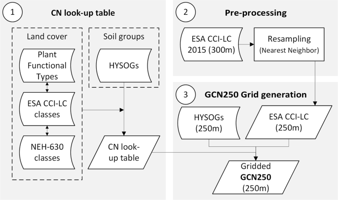
GCN250是一个全球一致的网格化数据集,根据新的全球土地覆盖(300米)和土壤数据(250米)定义250米空间分辨率的CN
全球水文曲线编号(GCN250)¶。
GCN250是一个全球一致的网格化数据集,根据新的全球土地覆盖(300米)和土壤数据(250米)定义250米空间分辨率的CN。GCN250代表了欧洲航天局2015年全球土地覆盖数据集(ESA CCI-LC)重新采样到250米并与2018年发布的水文土壤组全球数据产品(HYSOGs250m)进行地理登记的组合的径流。该数据的潜在应用包括水文设计、土地管理应用、洪水风险评估和地下水补给建模。CN值的变化取决于先期径流条件(ARC),它受降雨强度和持续时间、总降雨量、土壤水分条件、覆盖密度、生长阶段和温度的影响.
文献引用:
| Design Type(s) |
modeling and simulation objective • data integration objective |
| Measurement Type(s) |
hydrological process |
| Technology Type(s) |
computational modeling technique |
| Factor Type(s) |
geographic location • hydrological process • soil • land use |
| Sample Characteristic(s) |
Earth (Planet) • soil • land • ecosystem • hydrological process |
(ISA-Tab format)
代码:
代码链接:
Extra Info: Dataset is also available as an Earth Engine App (Global Hydrologic Curve Number Explorer) It allows users to visualize the gridded hydrologic curve number dataset at ~250m resolution globally.
Link to the app:
Link to app code:
License
This work is distributed under the Creative Commons Attribution 4.0 International License
Created and Curated by: Hadi H. Jaafar, Farah A. Ahmad, Naji El Beyrouthy
Keywords: Curve Number, Runoff, Hydrology
Last updated: 2019-06-20

- 点赞
- 收藏
- 关注作者


评论(0)