GEE数据集:全球土壤属性数据集800m网格
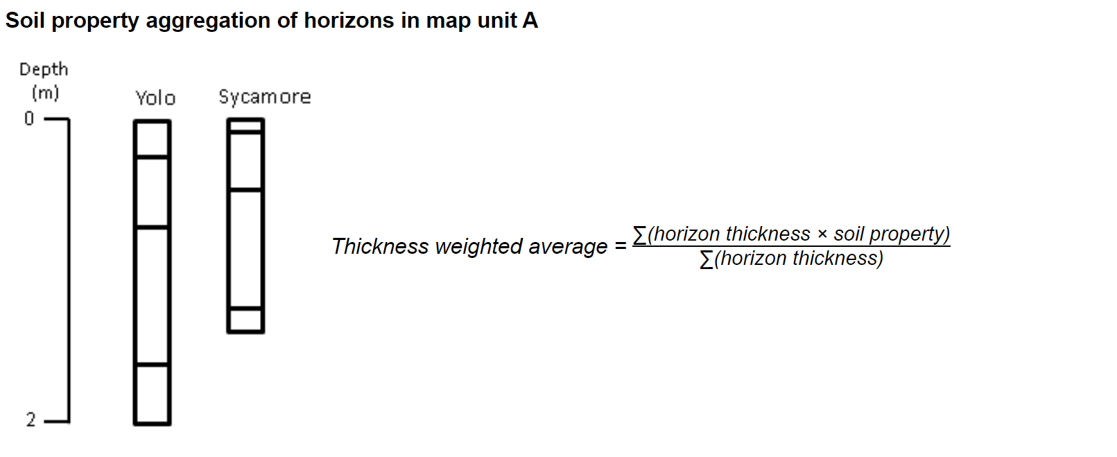
这里显示的数据是通过在800m²的网格单元内汇总当前USDA-NCSS的土壤调查数据(在没有SSURGO的地方用STATSGO回填)获得的。这种数据汇总技术导致地图可能与任何特定点的原始数据不一致,其目的是在全州范围内描述土壤属性的区域趋势。
这个应用程序是由加州大学戴维斯分校的加州土壤资源实验室和加州大学ANR与美国农业部自然资源保护局合作开发的。本网站和网格化数据产品请使用以下引文。
引文:
Walkinshaw, Mike, A.T. O'Geen, D.E. Beaudette. "Soil Properties." California Soil Resource Lab, 1 Oct. 2020,casoilresource.lawr.ucdavis.edu/soil-properties/.
Citation
| Property Type | Property Name | GEE asset |
|---|---|---|
| Chemical | Calcium Carbonate | projects/earthengine-legacy/assets/projects/sat-io/open-datasets/CSRL_soil_properties/chemical/caco3 |
| Cation Exchange Capacity | projects/earthengine-legacy/assets/projects/sat-io/open-datasets/CSRL_soil_properties/chemical/cec | |
| Cation Exchange Capacity (0-5cm) | projects/earthengine-legacy/assets/projects/sat-io/open-datasets/CSRL_soil_properties/chemical/cec_profile | |
| Cation Exchange Capacity (0-25 cm) | projects/earthengine-legacy/assets/projects/sat-io/open-datasets/CSRL_soil_properties/chemical/cec_profile | |
| Cation Exchange Capacity (0-50 cm) | projects/earthengine-legacy/assets/projects/sat-io/open-datasets/CSRL_soil_properties/chemical/cec_profile | |
| Electrical Conductivity | projects/earthengine-legacy/assets/projects/sat-io/open-datasets/CSRL_soil_properties/chemical/ec | |
| Electrical Conductivity (0-5 cm) | projects/earthengine-legacy/assets/projects/sat-io/open-datasets/CSRL_soil_properties/chemical/ec_profile | |
| Electrical Conductivity (0-25 cm) | projects/earthengine-legacy/assets/projects/sat-io/open-datasets/CSRL_soil_properties/chemical/ec_profile | |
| pH | projects/earthengine-legacy/assets/projects/sat-io/open-datasets/CSRL_soil_properties/chemical/ph | |
| pH (0-5 cm) | projects/earthengine-legacy/assets/projects/sat-io/open-datasets/CSRL_soil_properties/chemical/ph_profile | |
| pH (0-25 cm) | projects/earthengine-legacy/assets/projects/sat-io/open-datasets/CSRL_soil_properties/chemical/ph_profile | |
| pH (25-50 cm) | projects/earthengine-legacy/assets/projects/sat-io/open-datasets/CSRL_soil_properties/chemical/ph_profile | |
| pH (30-60 cm) | projects/earthengine-legacy/assets/projects/sat-io/open-datasets/CSRL_soil_properties/chemical/ph_profile | |
| Sodium Adsorption Ratio | projects/earthengine-legacy/assets/projects/sat-io/open-datasets/CSRL_soil_properties/chemical/sar | |
| Soil Organic Matter | projects/earthengine-legacy/assets/projects/sat-io/open-datasets/CSRL_soil_properties/chemical/som | |
| Soil Organic Matter- Max | projects/earthengine-legacy/assets/projects/sat-io/open-datasets/CSRL_soil_properties/chemical/som_max | |
| Physical | Avail. Water Holding Capacity | projects/earthengine-legacy/assets/projects/sat-io/open-datasets/CSRL_soil_properties/physical/water_storage |
| Avail. Water Holding Capacity (0-25cm) | projects/earthengine-legacy/assets/projects/sat-io/open-datasets/CSRL_soil_properties/physical/water_storage_profile | |
| Avail. Water Holding Capacity (0-50cm) | projects/earthengine-legacy/assets/projects/sat-io/open-datasets/CSRL_soil_properties/physical/water_storage_profile | |
| Bulk Density | projects/earthengine-legacy/assets/projects/sat-io/open-datasets/CSRL_soil_properties/physical/bulk_density | |
| Drainage Class | projects/earthengine-legacy/assets/projects/sat-io/open-datasets/CSRL_soil_properties/physical/drainage_class | |
| Rock Fragments (0-25cm) | projects/earthengine-legacy/assets/projects/sat-io/open-datasets/CSRL_soil_properties/physical/rf_025 | |
| Sat. Hyd. Conductivity (Ksat) - Mean | projects/earthengine-legacy/assets/projects/sat-io/open-datasets/CSRL_soil_properties/physical/ksat_mean | |
| Sat. Hyd. Conductivity (Ksat) - Min | projects/earthengine-legacy/assets/projects/sat-io/open-datasets/CSRL_soil_properties/physical/ksat_min | |
| Sat. Hyd. Conductivity (Ksat) - Max | projects/earthengine-legacy/assets/projects/sat-io/open-datasets/CSRL_soil_properties/physical/ksat_max | |
| Sat. Hyd. Conductivity (Ksat) - (0-5 cm) | projects/earthengine-legacy/assets/projects/sat-io/open-datasets/CSRL_soil_properties/physical/ksat_05 | |
| Soil Texture (0 - 5 cm) | projects/earthengine-legacy/assets/projects/sat-io/open-datasets/CSRL_soil_properties/physical/soil_texture_profile | |
| Soil Texture (0 - 25 cm) | projects/earthengine-legacy/assets/projects/sat-io/open-datasets/CSRL_soil_properties/physical/soil_texture_profile | |
| Soil Texture (25 - 50 cm) | projects/earthengine-legacy/assets/projects/sat-io/open-datasets/CSRL_soil_properties/physical/soil_texture_profile | |
| Sand | projects/earthengine-legacy/assets/projects/sat-io/open-datasets/CSRL_soil_properties/physical/sand | |
| Sand (0-5 cm) | projects/earthengine-legacy/assets/projects/sat-io/open-datasets/CSRL_soil_properties/physical/sand_profile | |
| Sand (0-25 cm) | projects/earthengine-legacy/assets/projects/sat-io/open-datasets/CSRL_soil_properties/physical/sand_profile | |
| Sand (25-50 cm) | projects/earthengine-legacy/assets/projects/sat-io/open-datasets/CSRL_soil_properties/physical/sand_profile | |
| Sand (30-60 cm) | projects/earthengine-legacy/assets/projects/sat-io/open-datasets/CSRL_soil_properties/physical/sand_profile | |
| Silt | projects/earthengine-legacy/assets/projects/sat-io/open-datasets/CSRL_soil_properties/physical/silt | |
| Silt (0-5 cm) | projects/earthengine-legacy/assets/projects/sat-io/open-datasets/CSRL_soil_properties/physical/silt_profile | |
| Silt (0-25 cm) | projects/earthengine-legacy/assets/projects/sat-io/open-datasets/CSRL_soil_properties/physical/silt_profile | |
| Silt (25-50 cm) | projects/earthengine-legacy/assets/projects/sat-io/open-datasets/CSRL_soil_properties/physical/silt_profile | |
| Silt (30-60 cm) | projects/earthengine-legacy/assets/projects/sat-io/open-datasets/CSRL_soil_properties/physical/silt_profile | |
| Clay | projects/earthengine-legacy/assets/projects/sat-io/open-datasets/CSRL_soil_properties/physical/clay | |
| Clay (0-5 cm) | projects/earthengine-legacy/assets/projects/sat-io/open-datasets/CSRL_soil_properties/physical/clay_profile | |
| Clay (0-25 cm) | projects/earthengine-legacy/assets/projects/sat-io/open-datasets/CSRL_soil_properties/physical/clay_profile | |
| Clay (25-50 cm) | projects/earthengine-legacy/assets/projects/sat-io/open-datasets/CSRL_soil_properties/physical/clay_profile | |
| Clay (30-60 cm) | projects/earthengine-legacy/assets/projects/sat-io/open-datasets/CSRL_soil_properties/physical/clay_profile | |
| Land Use | Depth to Restrictive Layer | projects/earthengine-legacy/assets/projects/sat-io/open-datasets/CSRL_soil_properties/land_use/resdept |
| Hydrologic Group | projects/earthengine-legacy/assets/projects/sat-io/open-datasets/CSRL_soil_properties/land_use/hydrologic_group | |
| Kw Factor (0 - 25 cm) | projects/earthengine-legacy/assets/projects/sat-io/open-datasets/CSRL_soil_properties/land_use/kw_025 | |
| Land Capability Class - Non-Irrigated | projects/earthengine-legacy/assets/projects/sat-io/open-datasets/CSRL_soil_properties/land_use/lcc_ni | |
| Land Capability Class - Irrigated | projects/earthengine-legacy/assets/projects/sat-io/open-datasets/CSRL_soil_properties/land_use/lcc_i | |
| Soil Depth | projects/earthengine-legacy/assets/projects/sat-io/open-datasets/CSRL_soil_properties/land_use/soil_depth | |
| Soil Order | projects/earthengine-legacy/assets/projects/sat-io/open-datasets/CSRL_soil_properties/land_use/soil_order | |
| Soil Temperature Regime | projects/earthengine-legacy/assets/projects/sat-io/open-datasets/CSRL_soil_properties/land_use/soil_temp_regime | |
| Wind Erodibility Group | projects/earthengine-legacy/assets/projects/sat-io/open-datasets/CSRL_soil_properties/land_use/wind_erodibility_group | |
| Wind Erodibility Index | projects/earthengine-legacy/assets/projects/sat-io/open-datasets/CSRL_soil_properties/land_use/wind_erodibility_index | |
| Survey Type | projects/earthengine-legacy/assets/projects/sat-io/open-datasets/CSRL_soil_properties/land_use/survey_type | |
| Soil Color | Soil Color (10 cm) | projects/earthengine-legacy/assets/projects/sat-io/open-datasets/CSRL_soil_properties/soil_color |
| Soil Color (25 cm) | projects/earthengine-legacy/assets/projects/sat-io/open-datasets/CSRL_soil_properties/soil_color | |
| Soil Color (75 cm) | projects/earthengine-legacy/assets/projects/sat-io/open-datasets/CSRL_soil_properties/soil_color | |
| Soil Color (125 cm) | projects/earthengine-legacy/assets/projects/sat-io/open-datasets/CSRL_soil_properties/soil_color |
Soil Aggregation Details
预处理
对于具有深度剖面的图层,将创建一个具有最小深度和最大深度属性的_剖面集合,然后可用于过滤,并允许不同的剖面留在单一属性的图像集合中,例如沙和沙_剖面。
你可以在这里下载数据层,以及分类而非连续的层的查询表。同时,模式金字塔策略也适用于所有的分类图层,你可以在下载页面找到所有分类变量的查询表。
代码:
代码连接“
土壤纹理调色板
调色板已经为变量类型创建,下面是一个土壤纹理的调色板。一些调色板包括rgb值,可以为每个变量类型转换为十六进制代码。这些调色板可以从应用程序页面中提取,有几个调色板包含在示例代码中。
| #BEBEBE | Sand |
| #FDFD9E | Loamy Sand |
| #ebd834 | Sandy Loam |
| #307431 | Loam |
| #CD94EA | Silt Loam |
| #546BC3 | Silt |
| #92C158 | Sandy Clay Loam |
| #EA6996 | Clay Loam |
| #6D94E5 | Silty Clay Loam |
| #4C5323 | Sandy Clay |
| #E93F4A | Silty Clay |
| #AF4732 | Clay |
土壤分类代码连接:
Shared License
This work is licensed under a Creative Commons Attribution 4.0 International and is an open license unless otherwise indicated. You must give appropriate credit, provide a link to the license, and indicate if changes were made.
Created by : California Soil Resource Lab at UC Davis and UC-ANR in collaboration with the USDA Natural Resources Conservation Service
Curated in GEE by: Samapriya Roy
Keywords: Soil grid, USDA, CSRL, UCANR,USDA, Soil, Coarse
Last updated: 2021-07-22
- 点赞
- 收藏
- 关注作者


评论(0)