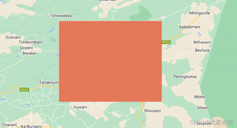
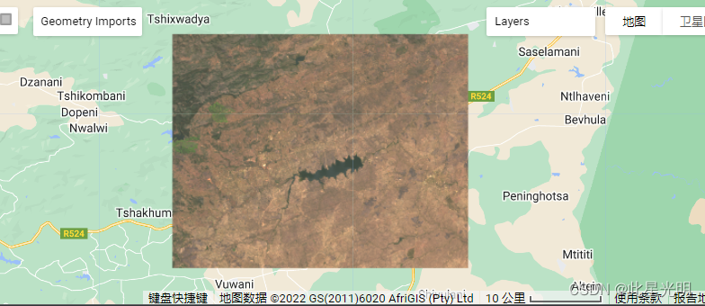
gee——影像无法正常加载和影像下载后数据异常

举报
此星光明 发表于 2022/11/24 23:23:18 2022/11/24
【摘要】 ​当我们下载或者展示影像的时候会出现错误,本文主要解决两个问题,第一个就是解决影像展示的问题,展示如果不能正常显示影像的RGB影像,一般情况下主要出现的问题就在于最大值和最小值的设定,如果你不知道该如何设置,就直接去掉min和max的设置。这样也能正常显示,Map.addLayer(eeObject, visParams, name, shown, opacity)Adds a given ...

当我们下载或者展示影像的时候会出现错误,本文主要解决两个问题,第一个就是解决影像展示的问题,展示如果不能正常显示影像的RGB影像,一般情况下主要出现的问题就在于最大值和最小值的设定,如果你不知道该如何设置,就直接去掉min和max的设置。这样也能正常显示,

Map.addLayer(eeObject, visParamsnameshownopacity)

Adds a given EE object to the map as a layer.

Returns the new map layer.

Arguments:

eeObject (Collection|Feature|Image|RawMapId):

The object to add to the map.

visParams (FeatureVisualizationParameters|ImageVisualizationParameters, optional):

The visualization parameters. For Images and ImageCollection, see ee.data.getMapId for valid parameters. For Features and FeatureCollections, the only supported key is "color", as a CSS 3.0 color string or a hex string in "RRGGBB" format. Ignored when eeObject is a map ID.

name (String, optional):

The name of the layer. Defaults to "Layer N".

shown (Boolean, optional):

A flag indicating whether the layer should be on by default.

opacity (Number, optional):

The layer's opacity represented as a number between 0 and 1. Defaults to 1.

Returns: ui.Map.Layer

原始代码:

var roi = 
    /* color: #d63000 */
    /* displayProperties: [
      {
        "type": "rectangle"
      }
    ] */
    ee.Geometry.Polygon(
        [[[30.335363045782245, -22.81645461186883],
          [30.335363045782245, -23.114862567618875],
          [30.74597705945412, -23.114862567618875],
          [30.74597705945412, -22.81645461186883]]], null, false);

// Exporting Lansat 8 images

// Load Landsat 8 
var image= ee.ImageCollection("LANDSAT/LC08/C02/T1_L2")
.filterDate("2017-01-01", "2017-12-31")
.filterBounds(roi)
.sort("CLOUD_COVER")
.first();

var vispaaramsTrue = {bands: ["SR_B4", "SR_B3", "SR_B2"], min: 0, max: 3000, gamma:1.4};
Map.addLayer(image.clip(roi), vispaaramsTrue, "Landsat 2017");
Map.centerObject(roi, 10);

// Export to drive
Export.image.toDrive({
image: image,
description: "Landsat2017Thohoyandou",
scale: 30,
region: roi,
maxPixels: 1e13
});


修改后的代码:

// Exporting Lansat 8 images

// Load Landsat 8 
var image= ee.ImageCollection("LANDSAT/LC08/C02/T1_L2")
.filterDate("2017-01-01", "2017-12-31")
.filterBounds(roi)
.sort("CLOUD_COVER")
.first();

print(image)

var vispaaramsTrue = {bands: ["SR_B4", "SR_B3", "SR_B2"], min: 5000, max: 15000};
Map.addLayer(image.clip(roi), vispaaramsTrue, "Landsat 2017");
Map.centerObject(roi, 10);

// Export to drive
Export.image.toDrive({
image: image,
description: "Landsat2017Thohoyandou",
scale: 30,
region: roi,
maxPixels: 1e13
});


这里值得注意的是我们在下载影像的时候,我们必须得完成影像的的mosaic而不是使用.first()因为你下载first,你只能下载第一景影像而不是所有指定时间范围内的影像数据的聚合类型。否则下来的就直接是黑色的,大家可以去尝试一下

2号通知|基于Python+TensorFlow/Pytorch深度学习的遥感科研与实践沙龙

MSG企业行·遥感卫星基于GEE云平台的生态遥感云计算

新手必备——10分钟快速了解谷歌地球引擎(GEE)

一文读懂Landsat Collection 2大气校正、地形校正等处理方式(文末有彩蛋)

GEE——利用sentinel2的NDVI影像进行水体和植被区分计算

【版权声明】本文为华为云社区用户原创内容,转载时必须标注文章的来源(华为云社区)、文章链接、文章作者等基本信息, 否则作者和本社区有权追究责任。如果您发现本社区中有涉嫌抄袭的内容,欢迎发送邮件进行举报,并提供相关证据,一经查实,本社区将立刻删除涉嫌侵权内容,举报邮箱: cloudbbs@huaweicloud.com
  • 点赞
  • 收藏
  • 关注作者

评论(0

0/1000
抱歉,系统识别当前为高风险访问,暂不支持该操作

全部回复

上滑加载中

设置昵称

在此一键设置昵称,即可参与社区互动!

*长度不超过10个汉字或20个英文字符,设置后3个月内不可修改。

*长度不超过10个汉字或20个英文字符,设置后3个月内不可修改。