GEE_全球冰川数据集下载

GLIMS Current: Global Land Ice Measurements From Space
全球陆地冰层空间测量(GLIMS)是一项国际倡议,目标是反复测量世界上估计的20万条冰川。
该项目旨在建立一个全球范围内的陆地冰层综合清单,包括冰川面积、几何形状、表面速度和雪线高度的测量。为了进行这些分析,GLIMS项目使用了卫星数据,主要来自高级星载热发射和反射辐射计(ASTER)和大地卫星增强型专题成像仪(ETM+),以及来自地图和航空照片的历史信息。
这个数据集中的每个特征都是分析时的冰川的多边形边界。几个冰川的ID在一段时间内有数百个不同的行。
这个数据集是截至2021年9月14日的冰川边界清单的快照,提供了超过690,000行。
Dataset Availability
1750-01-01T00:00:00 - 2019-07-18T00:00:00
Dataset Provider
Collection Snippet
ee.FeatureCollection("GLIMS/current")
FeatureView Snippet
ui.Map.FeatureViewLayer("GLIMS/current_FeatureView")
波段:这里有很多有用的信息,包括矢量的一些基础数据名称编号 长度等等
| Name | Type | Description |
|---|---|---|
| analysts | String | Name(s) of data contributor(s) |
| anlys_id | Double | ID of a glacier at a particular time |
| anlys_time | String | When the analysis was done |
| area | Double | Area of the glacier in the plane of the map projection in square kilometers |
| chief_affl | String | Affiliation of the chief of the regional center |
| db_area | Double | Same as 'area', but recomputed by the GLIMS project |
| geog_area | String | Name of geographic region covered by the regional center |
| glac_id | String | The GLIMS glacier ID |
| glac_name | String | The glacier name. ~80% of the rows equal 'None' |
| glac_stat | String | Glacier status, either 'exists' or 'None' |
| length | Double | Length of the glacier perimeter in meters |
| line_type | String | Glacier record type, e.g. 'glac_bound' for glaciers, or other values for internal rocks, snowlines, water features, etc. |
| local_id | String | ID assigned by the contributing institution or regional center |
| max_elev | Double | Highest part of the glacier, in meters above sea level |
| mean_elev | Double | Mean elevation of the glacier, in meters above sea level |
| min_elev | Double | Lowest part of the glacier, in meters above sea level |
| parent_id | String | ID of the glacier that is the parent of this glacier |
| primeclass | Double | WGMS glacier classification number |
| proc_desc | String | Description of processing done on this record |
| rc_id | Double | ID used by the regional center |
| rec_status | String | Record status |
| release_dt | String | Date data was released, in YYYY-MM-ddTHH:mm:ss format |
| src_date | String | Date of source imagery used to create the outline |
| subm_id | Double | The submission ID assigned by GLIMS |
| submitters | String | Name(s) of data submitter(s) |
| wgms_id | String | World Glacier Monitoring Service ID |
| width | Double | Width of the glacier in meters |
使用说明:
对于创建任何报告、出版物、新数据集、衍生产品或由数据集产生的服务,用户应引用。GLIMS和NSIDC(2005年,2013年更新)。全球陆地空间冰川测量数据库。由国际GLIMS团体和美国国家冰雪数据中心(Boulder CO, U.S.A.)编撰并提供,doi:10.7265/N5V98602
FeatureView ID
GLIMS/current_FeatureViewIngestion parameters
| Thinning option | Value |
|---|---|
| Max features per tile | 12000 |
| Thinning strategy | Higher density |
| Thinning ranking rule | Direction |
|---|---|
| Attribute: area | Descending |
| Z-order ranking rule | Direction |
|---|---|
| Attribute: area | Descending |
sourceVersion
2021-09-16T02:15:21.360958Z
代码:
var fvLayer = ui.Map.FeatureViewLayer('GLIMS/current_FeatureView');

var visParams = {
  color: {
    property: 'area',
    mode: 'linear',
    palette: ['gray', 'cyan', 'blue'],
    min: 0.0,
    max: 10.0
  },
  opacity: 0.8,
  polygonStrokeOpacity: 0
};

fvLayer.setVisParams(visParams);
fvLayer.setName('GLIMS/current');

Map.setCenter(-35.618, 66.743, 7);
Map.add(fvLayer);
//下载链接
var fvLayer1 = ee.FeatureCollection("GLIMS/current").geometry()
Export.table.toDrive({collection:fvLayer1,
description:'landice', folder:'ice',  fileFormat:'SHP'})
提示:这里我这个矢量比较大,所以建议大家用自己的研究区去裁剪,这样有利于合理的资源,简化下载时间。这里我在写代码的时候有一个问题,就是我们需要
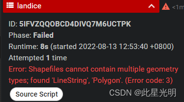
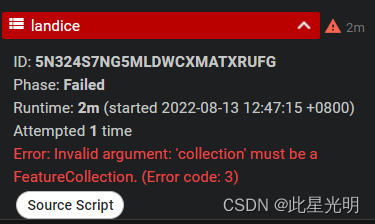
这里面提示了两个错误一个是geometry加了之后显示必须是一个矢量集合才能下载,上面的那张图错误是我们不添加任何东西造成的错误,显示了包含多个属性,不是一个全面的面数据,里面包含有多段线数据。
正确的代码就是:
var fvLayer1 = ee.FeatureCollection("GLIMS/current").union()//.map(feature)
Export.table.toDrive({collection:fvLayer1,
description:'landice', folder:'ice',  fileFormat:'SHP'})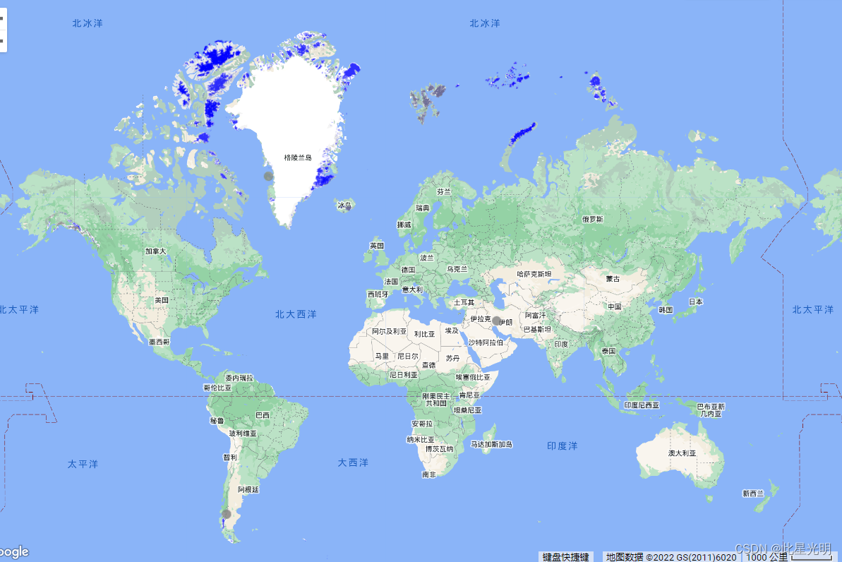

- 点赞
- 收藏
- 关注作者
评论(0)