Google Earth Engine(GEE)——全球建筑物矢量图免费下载Open Buildings V1 Polygons

之前我们已经介绍过了关于微软全球建筑物提取的矢量图:
数据介绍:
这个大规模的开放数据集包括从高分辨率的50厘米卫星图像中得出的建筑物轮廓。它包含了5.16亿个建筑物的检测结果,覆盖了1940万平方公里的区域(占非洲大陆的64%)。
对于这个数据集中的每一栋建筑,我们都包括描述其在地面上的足迹的多边形、表明我们对这是一栋建筑的确定程度的信心分数,以及与建筑中心相对应的Plus代码。没有关于建筑物类型、街道地址或除几何形状以外的任何细节的信息。
建筑物足迹对一系列重要的应用很有用:从人口估计、城市规划和人道主义反应到环境和气候科学。该项目设在加纳,目前的重点是非洲大陆。
推断工作是在2021年4月期间进行的。
时间:
2021-04-30T00:00:00 - 2021-04-30T00:00:00
Dataset Provider
Collection Snippet
ee.FeatureCollection("GOOGLE/Research/open-buildings/v1/polygons")
代码:
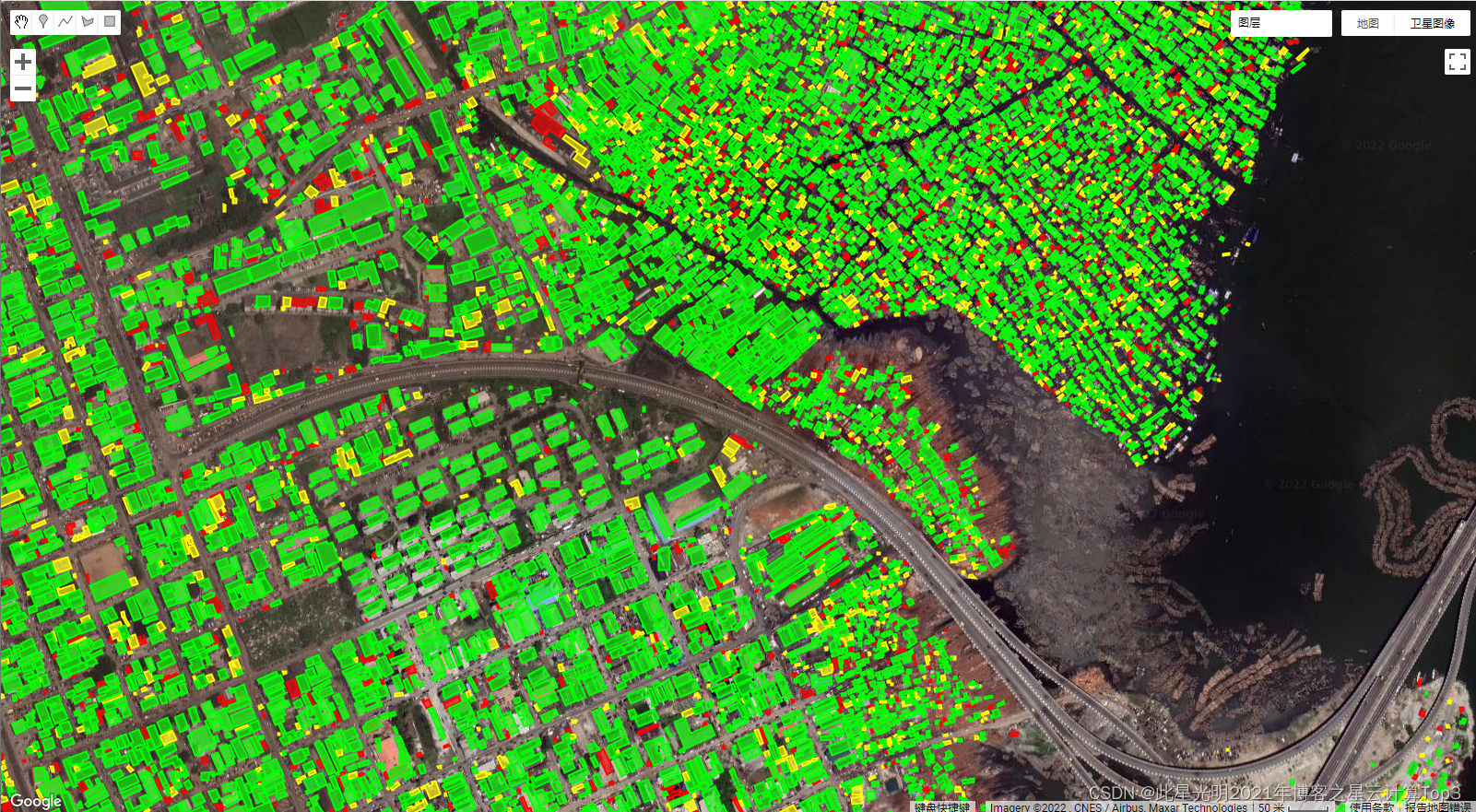
![]()
// Visualization of GOOGLE/Research/open-buildings/v1/polygons.

var t = ee.FeatureCollection('GOOGLE/Research/open-buildings/v1/polygons');

var t_060_065 = t.filter('confidence >= 0.60 && confidence < 0.65');
var t_065_070 = t.filter('confidence >= 0.65 && confidence < 0.70');
var t_gte_070 = t.filter('confidence >= 0.70');

Map.addLayer(t_060_065, {color: 'FF0000'}, 'Buildings confidence [0.60; 0.65)');
Map.addLayer(t_065_070, {color: 'FFFF00'}, 'Buildings confidence [0.65; 0.70)');
Map.addLayer(t_gte_070, {color: '00FF00'}, 'Buildings confidence >= 0.70');
Map.setCenter(3.389, 6.492, 17);  // Lagos, Nigeria
Map.setOptions('SATELLITE');
![]()

![]()
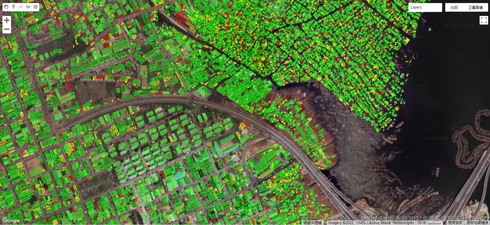
FeatureView Snippet(快速加载矢量的最新方法,没有瓦片感)
ui.Map.FeatureViewLayer("GOOGLE/Research/open-buildings/v1/polygons_FeatureView")
代码:
var fvLayer = ui.Map.FeatureViewLayer(
  'GOOGLE/Research/open-buildings/v1/polygons_FeatureView');

var visParams = {
  rules: [
    {
      filter: ee.Filter.expression('confidence >= 0.60 && confidence < 0.65'),
      color: 'FF0000'
    },
    {
      filter: ee.Filter.expression('confidence >= 0.65 && confidence < 0.70'),
      color: 'FFFF00'
    },
    {
      filter: ee.Filter.expression('confidence >= 0.70'),
      color: '00FF00'
    },
  ]
};

fvLayer.setVisParams(visParams);
fvLayer.setName('Buildings');

Map.setCenter(3.389, 6.492, 17);  // Lagos, Nigeria
Map.add(fvLayer);
Map.setOptions('SATELLITE');
FeatureView ID
GOOGLE/Research/open-buildings/v1/polygons_FeatureView
Ingestion parameters
| Thinning option | Value |
|---|---|
| Max features per tile | 12000 |
| Thinning strategy | Higher density |
sourceVersion
2021-07-20T21:22:23.620127Z
波段:
| Name | Type | Description |
|---|---|---|
| area_in_meters | Double | Area in square meters of the polygon. |
| confidence | Double | Confidence score [0.5;1.0] assigned by the model. |
| full_plus_code | String | The full [Plus Code](https://plus.codes/) at the building polygon centroid. |
| longitude_latitude | undefined | Centroid of the polygon. |
数据引用:
W. Sirko, S. Kashubin, M. Ritter, A. Annkah, Y.S.E. Bouchareb, Y. Dauphin, D. Keysers, M. Neumann, M. Cisse, J.A. Quinn. Continental-scale building detection from high resolution satellite imagery. , 2021.

- 点赞
- 收藏
- 关注作者
评论(0)