GEE(Google Earth Engine)投影的使用方法和分辨率的确定
projection()
Returns the default projection of an Image. Throws an error if the bands of the image don't all have the same projection.
返回图像的默认投影。如果图像的条带不都具有相同的投影,则会引发错误。
Arguments:
this:image (Image):
The image from which to get the projection.
Returns: Projection
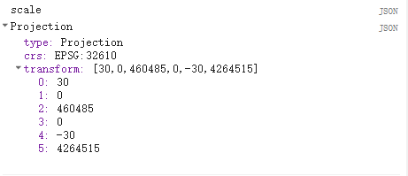
这是我通过打印获得到当前影像投影
crs:EPSG:32610这个就代表坐标系,具体参数可以去百度就能知道名称

第二个要介绍的:
nominalScale()
Returns the linear scale in meters of the units of this projection, as measured at the point of true scale.这个就是告诉你他的名义分辨率是多少,也就是影像的分辨率这里Landsat8是30米
Arguments:
this:proj (Projection)
Returns: Float
第三个方法:
bandNames()
Returns a list containing the names of the bands of an image.
返回一个包含图像波段名称的列表。
Arguments:
this:image (Image):
The image from which to get band names.
Returns: List

代码:
-
var image = ee.Image('LANDSAT/LC8_L1T/LC80440342014077LGN00')
-
.select(['B2', 'B3', 'B4', 'B5', 'B6', 'B7', 'B10', 'B11']);
-
var scale = image.projection().nominalScale();
-
var bandNames = image.bandNames();
-
print("scale",scale)
-
print("bandNames",bandNames)
文章来源: blog.csdn.net,作者:此星光明2021年博客之星云计算Top3,版权归原作者所有,如需转载,请联系作者。
原文链接:blog.csdn.net/qq_31988139/article/details/118936959
- 点赞
- 收藏
- 关注作者


评论(0)