GEE:Geomorpho90m全球数据集(还把梯度、崎岖程度、 地貌形态)

地形浮雕包括地球地形的垂直和水平变化,驱动着地貌学、生物地理学、气候学、水文学和生态学的进程。通过地貌测量和特征提取对其进行特征描述和评估,是众多环境建模和模拟分析的基础。因此,我们开发了Geomorpho90m全球数据集,包括从MERIT-数字高程模型(DEM)中提取的不同地貌特征,这是目前最好的全球高分辨率DEM。完全标准化的26个地貌变量由以下几层组成:(i) 使用一阶和二阶导数描述整个海拔梯度的变化率;(ii) 崎岖程度;(iii) 地貌形态。Geomorpho90m变量在WGS84大地基准下有3(~90米)和7.5角秒(~250米)分辨率,在Equi7投影下有100米空间分辨率。它们对地貌学、地质学、水文学、生态学和生物地理学等领域的建模应用非常有用。
Geomorpho90m是一套来自MERIT-DEM的地貌测量变量。这些变量有3种分辨率,摄入的是3角秒(~90米)的分辨率。这些图层可以从OpenTopography或Google Drive下载。在代码中展示的三个影像图层分别为,这里有三个变量或者指数:
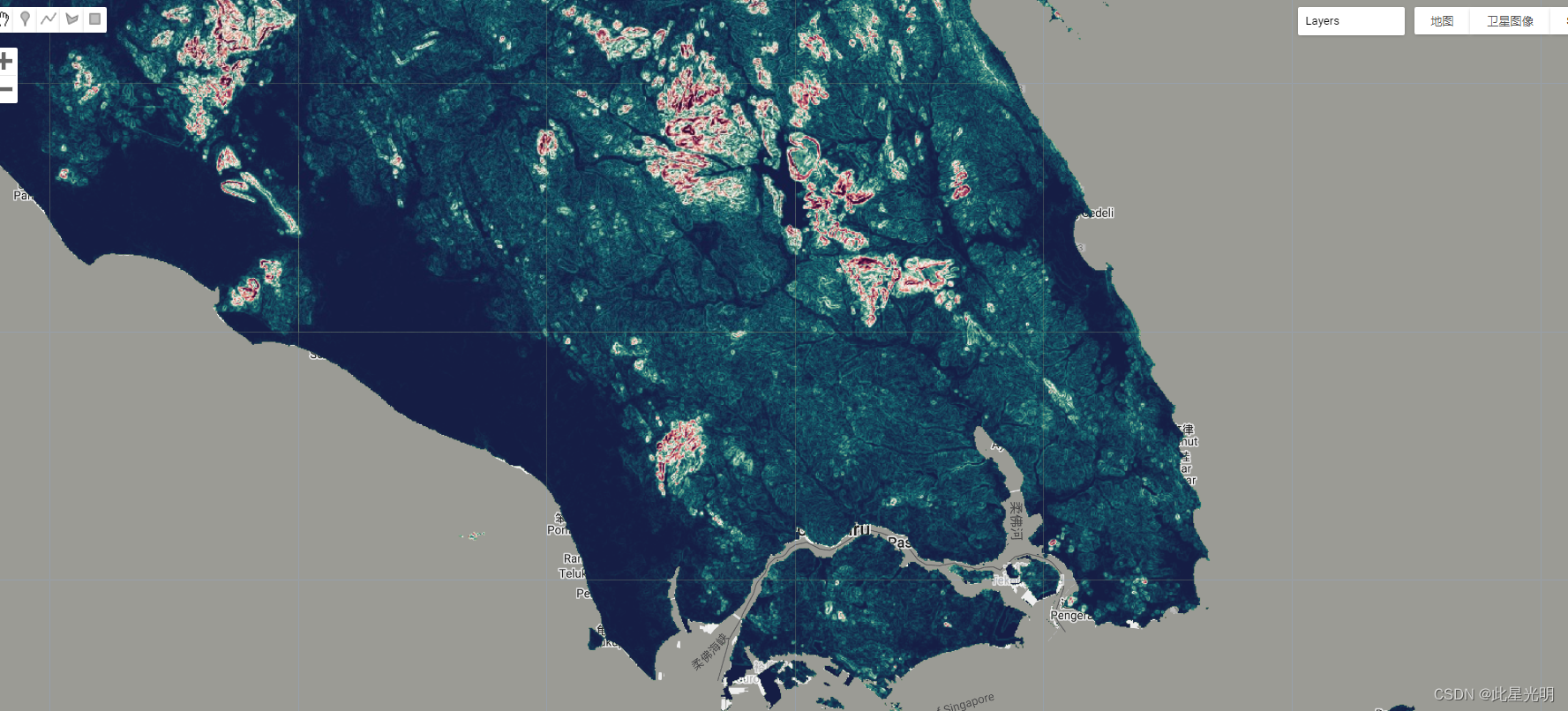
- Compound Topographic Index (CTI) 复合地形指数 (CTI)
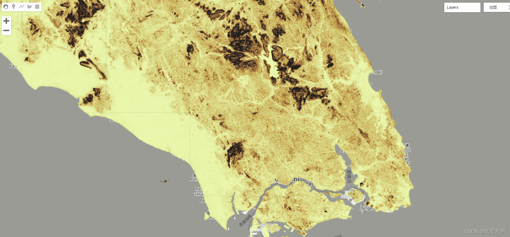
- Terrain Ruggedness Index (TRI) 地形坚固性指数 (TRI)
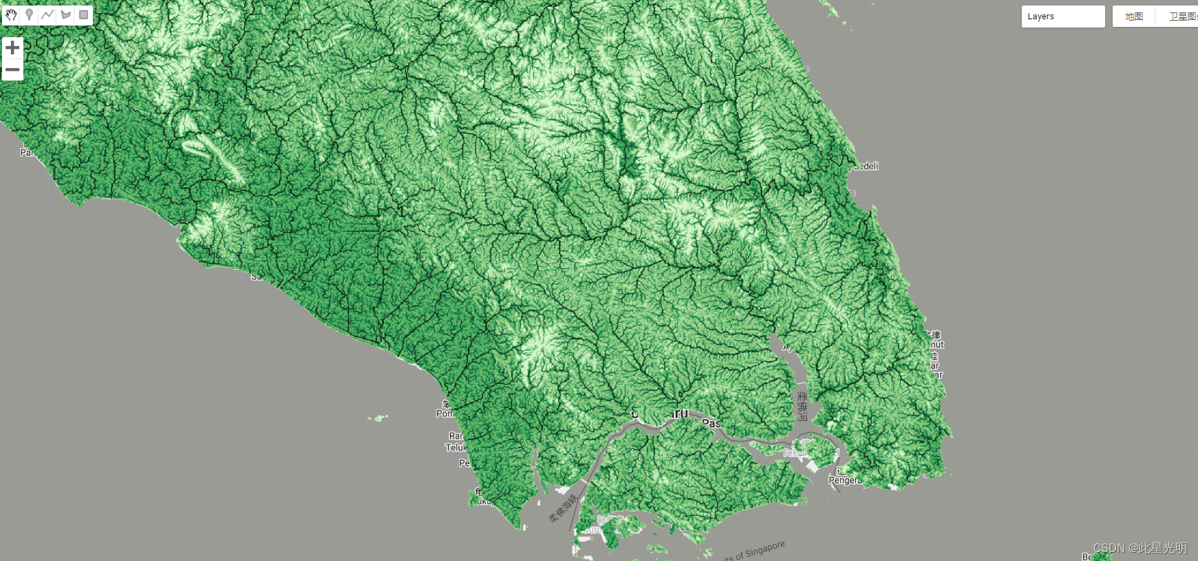
- Slope Median 坡度中位数
数据引用:
Amatulli, Giuseppe, Daniel McInerney, Tushar Sethi, Peter Strobl, and Sami Domisch. "Geomorpho90m, empirical evaluation and accuracy assessment of global high-resolution geomorphometric layers." Scientific Data 7, no. 1 (2020): 1-18.
代码:
var cti = ee.ImageCollection("projects/sat-io/open-datasets/Geomorpho90m/cti");
var tri = ee.ImageCollection("projects/sat-io/open-datasets/Geomorpho90m/tri");
var slope = ee.ImageCollection("projects/sat-io/open-datasets/Geomorpho90m/slope");

var palettes = require('users/gena/packages:palettes')

//Center Map
Map.setCenter(103.7557, 1.6986,10)
print('CTI collection size',cti.size())
Map.addLayer(cti.median(), {min: -3, max: 6, palette: palettes.cmocean.Algae[7]}, 'Compound Topographic Index (CTI)')

print('TRI collection size',tri.size())
Map.addLayer(tri.median(), {min: 0.2, max:22, palette: palettes.cmocean.Turbid[7]}, 'Terrain Ruggedness Index (TRI)')

print('Slope collection size',slope.size())
Map.addLayer(slope.median(), {min: 0.2, max:25, palette: palettes.cmocean.Curl[7]}, 'Slope Median')

var SubtleGrayscale
 =
[
  {
    "featureType": "administrative",
    "elementType": "all",
    "stylers": [
      {
        "saturation": "-100"
      }
    ]
  },
  {
    "featureType": "administrative.province",
    "elementType": "all",
    "stylers": [
      {
        "visibility": "off"
      }
    ]
  },
  {
    "featureType": "landscape",
    "elementType": "all",
    "stylers": [
      {
        "saturation": -100
      },
      {
        "lightness": 65
      },
      {
        "visibility": "on"
      }
    ]
  },
  {
    "featureType": "poi",
    "elementType": "all",
    "stylers": [
      {
        "saturation": -100
      },
      {
        "lightness": "50"
      },
      {
        "visibility": "simplified"
      }
    ]
  },
  {
    "featureType": "road",
    "elementType": "all",
    "stylers": [
      {
        "saturation": "-100"
      }
    ]
  },
  {
    "featureType": "road.highway",
    "elementType": "all",
    "stylers": [
      {
        "visibility": "simplified"
      }
    ]
  },
  {
    "featureType": "road.arterial",
    "elementType": "all",
    "stylers": [
      {
        "lightness": "30"
      }
    ]
  },
  {
    "featureType": "road.local",
    "elementType": "all",
    "stylers": [
      {
        "lightness": "40"
      }
    ]
  },
  {
    "featureType": "transit",
    "elementType": "all",
    "stylers": [
      {
        "saturation": -100
      },
      {
        "visibility": "simplified"
      }
    ]
  },
  {
    "featureType": "water",
    "elementType": "geometry",
    "stylers": [
      {
        "hue": "#ffff00"
      },
      {
        "lightness": -25
      },
      {
        "saturation": -97
      }
    ]
  },
  {
    "featureType": "water",
    "elementType": "labels",
    "stylers": [
      {
        "lightness": -25
      },
      {
        "saturation": -100
      }
    ]
  }
]
Map.setOptions('SubtleGrayscale', {SubtleGrayscale
: SubtleGrayscale
})


var vrm = ee.ImageCollection("projects/sat-io/open-datasets/Geomorpho90m/vrm");
var roughness = ee.ImageCollection("projects/sat-io/open-datasets/Geomorpho90m/roughness");
var tpi = ee.ImageCollection("projects/sat-io/open-datasets/Geomorpho90m/tpi");
var spi = ee.ImageCollection("projects/sat-io/open-datasets/Geomorpho90m/spi");


//Import palette
var palettes = require('users/gena/packages:palettes')

//Center Map
Map.setCenter(91.1709, 29.3025,10)

//Add Layers
Map.addLayer(roughness.median(),{min: 0.01, max: 273.18, palette: palettes.cmocean.Turbid[7]},'Roughness')
Map.addLayer(tpi.median(), {min:-10.49281, max: 14.10036, palette: palettes.cmocean.Oxy[7]}, 'Topographic Position Index (TPI)')
Map.addLayer(vrm.median(),{min: 0.0000014, max: 0.044295, palette: palettes.cmocean.Matter[7]},'Vector Ruggedness Measure (VRM)')
Map.addLayer(spi.median().log(),{min: -8.3011414, max: 5.60854, palette: palettes.cmocean.Dense[7]},'Stream Power Index (SPI)')
样例代码链接:
Shared License: This work is licensed under a Creative Commons Attribution 4.0. You are free to copy and redistribute the material in any medium or format, and to transform and build upon the material for any purpose, even commercially. You must give appropriate credit, provide a link to the license, and indicate if changes were made.
Curated by: Samapriya Roy
Keywords: Geomorpho90m, geomorphometric layers, MERIT DEM, topographic index, terrain ruggedness index, slope
Last updated: 2021-04-04
gee:全球2014年至2021年的Bing地图图像中检测到777M的建筑数据集
GEE:WorldView-2和WorldView-3图像(每像素2米)制作的美国南部海岸湿地地区土地覆盖变化
GEE 错误:ImageCollection.error, argument 'images': Invalid type.

- 点赞
- 收藏
- 关注作者
评论(0)